Backcountry skiing and snowboarding is perfect for people who want to ride on less disturbed or untouched snow. If you are planning to travel to the backcountry, then it is important to understand how the weather on mountains work and what to do in different scenarios.
Temperature
Although temperature usually decreases as we travel higher in altitude, on mountains, the temperature tends to act a little strange. Under high pressure systems, only decreases in temperature with increasing altitude until a certain altitude. This altitude is called the tropopause and it acts as the upper limit of the troposphere layer in the atmosphere. Above the tropopause (~10 km), the temperature begins to increase with elevation. This layer is called the stratosphere. Since the colder air (in the troposphere) is found below the warmer air (the stratosphere), these layers are happy and statistically stable. This phenomena is called temperature inversion. Figure 1. shows a graph of temperature with increasing altitude when temperature inversion is occurring. It is important to understand this concept when preparing what to wear to travel up the mountain. It also is important for understanding the snow condition on the mountain. For instance, higher up the mountain, in the stratosphere where it is warmer, snow could be melting while at the bottom of the mountain it could be freezing forming a snow hoar.
Figure 1. 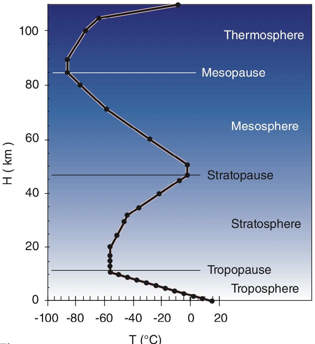
https://www.eoas.ubc.ca/courses/atsc113/snow/met_concepts/06-met_concepts/06c-inversions/
Additionally, in regions with high pressure systems and stable temperatures, cold air from the surface of the snow on the mountains can drift down the mountain to the bottom of valleys. This is called cold air pooling. Typically, cold air pooling occurs overnight as a result of katabatic winds (more info in "Background Information"). This is because nighttime is when temperatures are most stable as the sun isn't there to warm the snow surface and the surface of the snow undergoes radiative cooling. When cold air pooling happens, the cold air that drifted down from the mountain to the valley can be very cold and can form clouds fog called valley clouds and fog. Temperatures in the valleys can reach below freezing and form a special kind of fog called a freezing fog. Freezing fog itself does not present too much of hazard to a person as it only causes ice to form on your clothing. This ice is called rime ice. However, since ice can melt with body heat, the ice on your clothing can melt and leave you cold and wet so make sure to wear waterproof clothing to prevent this. The effects of cold air pooling can last past early morning as it takes the sun several hours for to warm valley bottoms and disperse the cold air pool. However, if a high pressure system stays in one area and there is a strong temperature inversion, it can cause cold air pools to last for several days. As such, if you are skiing or snowboarding during the night or early morning, please dress appropriately as the valley temperature is not indicative of the mountain temperature. Furthermore, if you are camping, do not set camp at the bottom of the valley where cold air pools, but on the mountainside. Information about fog hazards can be found in the "Hazards of Limited Visibility" page.
During the day, the sun can warm the snow surface. Since warm air rises, anabatic winds form and can creates cumulus clouds if the relative humidity is above 70%. When solar heating is strong, such as in late spring or summer, strong updrafts form and can cause rain and even thunderstorms. Although these winds are not hazardous, they are a good indicator for warmer temperatures.
Wind
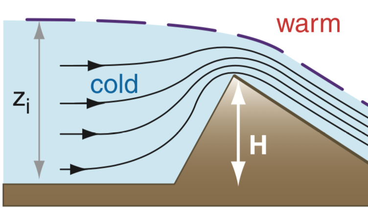
Mountain tops and ridgetops typically experience stronger winds than on flat surfaces. This is because as wind travels across a flat surface, the wind experiences friction and slows down. In contrast, mountain tops don't have that much area for the wind to slow down and instead gets hit head on by strong gusts of wind unless there are similar height mountain tops that can slow down the wind. Furthermore, when wind hits a mountain top, the wind becomes more restricted, as seen in figure 2. This concentrates the wind, causing a much faster wind and is called the Venturi or Bernoulli effect. As such, wind speeds are much stronger on mountain tops that at the ground level. When you travel down the mountain to the the mountainside, winds tend to be slightly weaker than at ridgetops and mountain tops as it is more sheltered. At the bottom in valleys, the winds are significantly weaker as it is very sheltered.
Hazards that are associated with winds can be found in the "Hazards of Wind" page.
Figure 2.
Precipitation
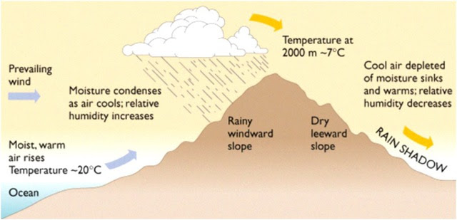
If there is a strong enough updraft, the increase in altitude can call the water vapors as it rises and form clouds and even a little bit of rain. If the temperature is cold enough, it can form snow as well. This can occur from either from the sun heating the ground causing the warm air to rise or from orographic uplift. Orographic uplift is when wind blows into a mountains and travels upward, like in figure 3. In BC, if the temperatures are cold enough, this can result in heavy snowfall which is great for skiing and snowboarding. On the other hand, if it isn't cold enough, rain and clouds form which are not great for skiing and snowboarding.
Figure 3.
https://www.eoas.ubc.ca/courses/atsc113/snow/met_concepts/06-met_concepts/06e-orographic-uplift-lee-shadowing/


 icons at the top right corner of the subsection.