1. Cloud Hazards and Thunderstorms
Clouds may seem like harmless balls of fluff, but to pilots and planes, clouds can pose many hazards to the performance of the pilots and the structural integrity of the plane itself. In this section, we will go in-depth on the 2 categories of common "normal clouds" and the risks they may pose to aircraft flying through them.
Convective/Cumuliform clouds (cu): These clouds are formed when warm humid air rise through the cooler and heavier cold air. Since warm air is less dense and lighter than warm air, the buoyancy of the warm air drives creates strong updrafts. These clouds are usually formed behind cold fronts, when sunshine warms the ground (creating buoyant warm air), near mountains, or when cold air blows over warmer water surfaces/land.
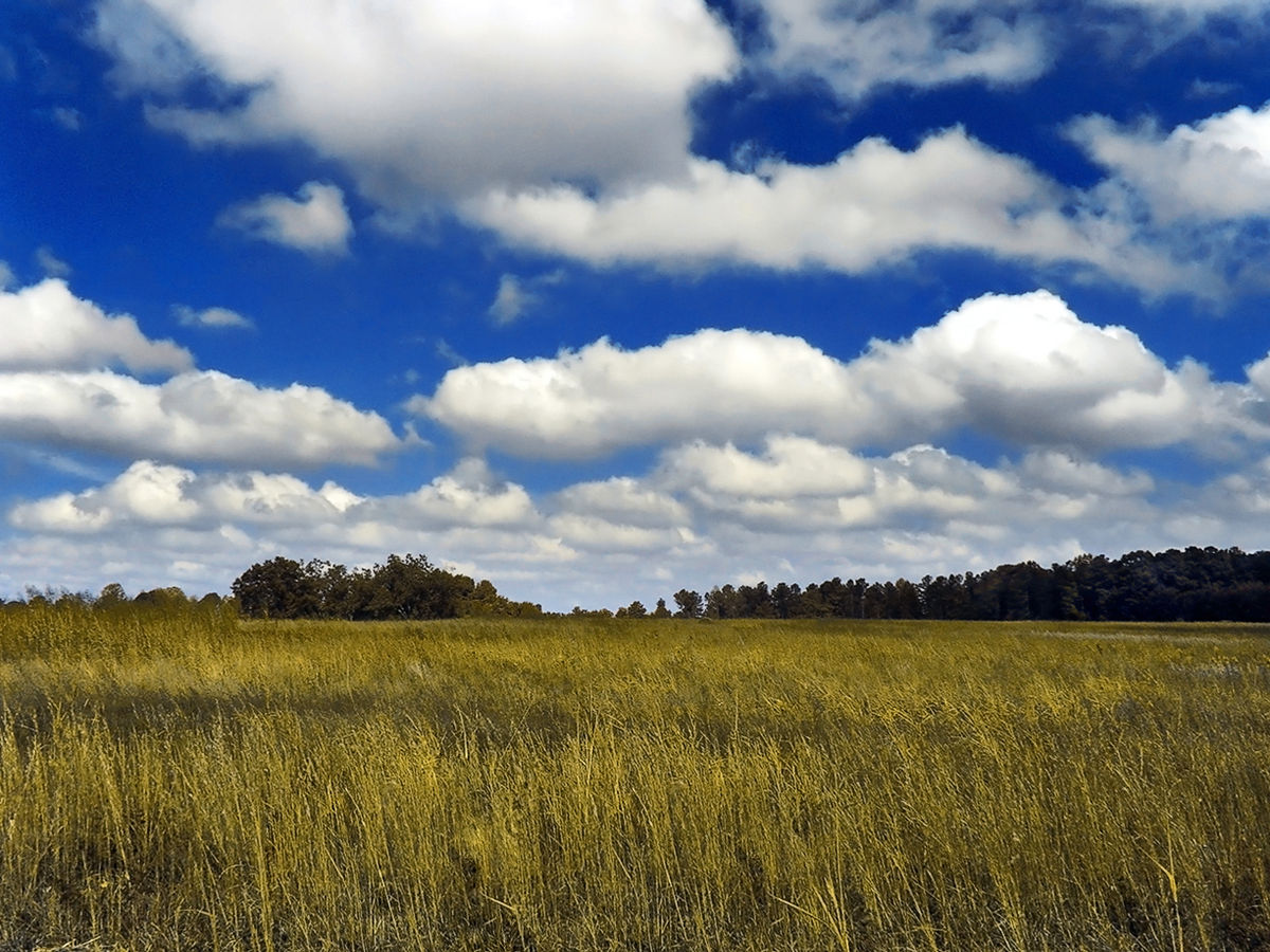
cumulus clouds, as seen from the ground (https://en.wikipedia.org/wiki/Cumulus_cloud, photo taken by PiccoloNamek, accessed Nov. 17th, 2021)
Identification:
-fluffy, looks like cotton balls
-usually has a wide flat base near the ground, where the cloud formation starts
4 depths of cumuliform clouds:
-Small: cumulus humilis, also known as "fair weather cumulus"
-Medium: cumulus mediocris
-Large: cumulus congestus, also known as towering cumulus
-Extra large: cumulonimbus, also called thunderstorms
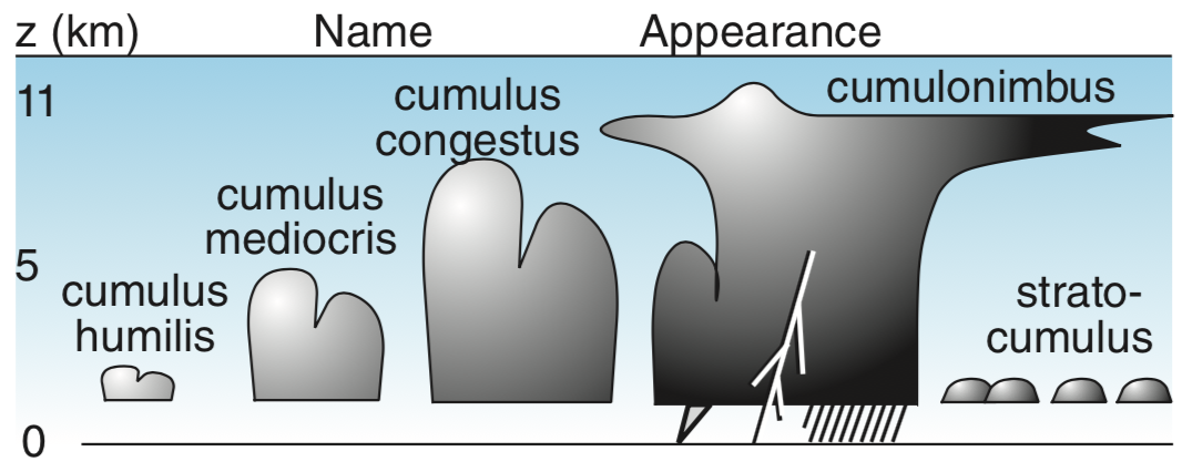
the 4 cumuliform cloud depths illustrated (https://www.eoas.ubc.ca/courses/atsc113/flying/met_concepts/01-met_concepts/01a-clouds/cumuliform.html, diagram by Roland Stull, accessed Nov. 17th, 2021)
The deeper the cumuliform cloud, the stronger the updrafts. Hence, pilots always try to steer clear of towering cumulus and thunderstorm clouds; these updrafts are so violent they can over-stress the aircraft and cause the pilot to completely lose control of the plane. Hence, the FAA (Federal Aviation Administration) recommend pilots stay at least 20 nautical miles away from thunderstorms. For instance, Clear Air Turbulence (CAT) can occur in the clear air beside thunderstorm clouds, therefore staying as far away from these clouds at all times is the best idea.
Unstable air, initial updraft, and high moisture content in the air are the basic requirements for the formation of thunderstorms. There are also many different types of thunderstorms, but generally, most types are composed of cells, with each cell representing a thunderstorm. The thunderstorm cell evolution starts with...
1. Cumulus: Usually not visible on radar, and only has updrafts
2. Mature: most violent stage, includes updrafts, downdrafts, rain, and anvil (horizontal upper part of cloud).
3. Dissipating: Downdrafts only, and starts to rain itself out. Ice crystals may form in the anvil section of thunderstorm cell.

Diagram showing the 3 stages of Thunderstorm cell evolution (accessed Nov. 17th, 2021) (http://globalsailingweather.com/thunderstorms.phpLinks to an external site.)
Smaller cumuliform cloud depths also pose a risk for planes flying through them. Turbulence often occurs when flying through these clouds, and they can sometimes seriously injure passengers and damage objects inside the plane.
~~~~~~~~~~~~~~~~~~~~~~~~~~~~~~~~~~~~~~~~~~~~~~~~~~~~~~~~~~~~~~~~~~~~~~
Layer clouds or stratiform clouds (St) are the second category of normal clouds. These clouds are formed at warm fronts, when the warm humid air slides on top of the heavier, denser cold air, creating a thick blanket of clouds that can extend for hundreds of kilometers horizontally.
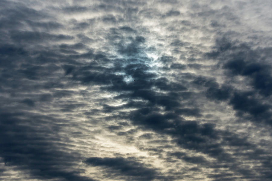
Stratiform clouds (covers the sky), (https://fineartamerica.com/featured/striated-clouds-douglas-killourie.html, photo taken by Douglas Killourie, Accessed Nov. 17th, 2021)
These clouds are classified into 3 groups, based on altitude:
-In higher altitudes, we see the formation of cirrus, cirrostratus, and cirrocumulus clouds
-In middle altitudes, altostratus and altocumulus clouds form instead
-In lower altitudes, stratus and nimbostratus clouds form.
Compared to cumuliform clouds, Stratiform clouds are generally not turbulent, hence the ride will usually be very smooth. However, the risk it poses to pilots is the reduced visibilities. Since these clouds extend hundreds of kilometers horizontally, pilots flying through them must be IFR-rated (instrument flight rules) (essentially relying on the instrumental readings to navigate the plane). For VFR pilots (visual flight rules), flying into these types of clouds could easily disorient the pilot, and the pilot must try to fly out of these clouds immediately.
Furthermore, nimbostratus clouds at lower altitudes are always precipitating, which can be another hazard for aircraft. In colder conditions, ice can also form on the leading edges of the plane due to supercooled liquid water droplets, which can decrease airflow and add additional weight to the plane.
~~~~~~~~~~~~~~~~~~~~~~~~~~~~~~~~~~~~~~~~~~~~~~~~~~~~~~~~~~~~~~~~~~
Below are some "special" types of clouds, which also have their own respective hazards to pilots and aircraft.
castellanus clouds look like castle turrets, and they are an indication that the atmosphere is becoming unstable, with thunderstorms possibly forming later on in the day
billow (K-H wave) clouds often have wind shear (change of wind speed or direction) and clear-air turbulence (CAT) at aircraft altitudes
lenticular (mountain-wave) clouds cause vertical wind oscillations, and lead to mountain wave turbulence
rotor clouds cause severe or extreme turbulence at low altitudes due to mountain waves; these clouds are extremely dangerous for pilots during takeoff and landing, since the winds are powerful enough to break off aircraft wings.
banner clouds form on the downwind side of a mountain peak, and often causes strong turbulence on the downside of the peak.
pyrocumulus clouds Form over forest fires and volcanoes, and can sometimes cause a thunderstorm in the smoke
fractus / scud clouds form in turbulent humid air near the ground, and can have strong winds
contrails clouds are formed by Aircraft condensation trail. They Indicate the turbulent wing-tip vortices behind aircraft, and can flip small aircraft upside down if they fly into it
~~~~~~~~~~~~~~~~~~~~~~~~~~~~~~~~~~~~~~~~~~~~~~~~~~~~~~~~~~~~~~~~~~~~
2. Obscuration and Visibility Hazards
Obscurations and Visibility are both major weather risks factors for pilots, as they can impair the pilot's performance and control of the aircraft. These factors are also extremely important depending on the pilot's certifications. VFR (visual rated) pilots should NEVER fly during cloudy or rainy days because their only means of navigation is by using visual references. When the sky is obscured, it would be impossible to see landmarks, bodies of water, buildings, and other aircraft, which creates a very dangerous flying scenario. IFR (instrumental rated) pilots, on the other hand, are permitted to fly under obscured conditions, but some scenarios are still too severe to safely operate the plane. Below are some common major visibility hazards:
Mist: occurs when very small precipitation droplets fall through the air, and usually occurs in areas with high relative humidity (>95% RH). Visibility is usually greater than 1km
Fog: reduces visibility to less than 1km. A fog is essentially a cloud that touches the ground; it is composed of tiny liquid droplets that are falling so slowly through the air, that they seem suspended. Usually formed when water is added to unsaturated air, or when unsaturated air is cooled to dew point temperature. Furthermore, fog occurs when wind is calm and often pools in lower elevation such as valleys.
Volcanic ash: consists of microscopic rocks with sharp edges. These ash can be extremely detrimental to a plane flying through ash clouds since they are very abrasive. If it gets into the engine, it can cause engine failure; if it enters the ventilation system, it can contaminate cabin air quality; it can also sandblast the windscreen, making it difficult to see; on rare occasions, ash can also cause a static electricity charge to build up, called St. Elmo's fire.
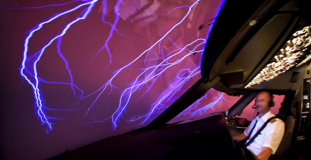
Surreal image of the St Elmo's fire phenomenon, viewed from the cockpit of a 747 (accessed Nov. 17th, 2021) (https://www.airlineratings.com/news/st-elmos-fire-light-show/Links to an external site.)
Sand: sand storms occur in windy desert regions, which create haboobs. Like ash, sand is very abrasive and can cause engine issues, reduce visibility, and create static charges, disrupting navigation instruments and systems.
Haze: consists of microscopic liquid water droplets that form around a pollutant particle or chemical that attracts water vapor; small haze particles are referred to as aerosols. examples include salt, sulfates, nitrates, and biological chemicals.
Spray: caused by ocean waves, which injects tiny droplets of saltwater into the atmosphere
Widespread Dust: Dust in the atmosphere can consist of a variety of microscopic solid substances (dirt, pollen, ashes, decaying biological material) stirred up into the atmosphere from the Earth's surface.
Snow and Blizzards: heavy snow has visibility less than 0.4 km, and moderate snow has visibility in the range 0.4 to 0.8 km. A blizzard occurs when blowing snow exceeds 40km/hr and causes reduced visibility less than 1km. Pilots often report a "white out" under severe blizzard conditions.

think twice before flying through weather like this.... (accessed Nov. 17th, 2021) (https://www.travelandleisure.com/travel-tips/flight-delays-after-stormLinks to an external site.)
oftentimes, glyphs and symbols are used on weather maps to indicate obscuration hazards. Text abbreviation of the hazard is also used on METARS. Below is an example of a glyph....

(accessed Nov. 17th, 2021) (table from https://www.eoas.ubc.ca/courses/atsc113/flying/met_concepts/01-met_concepts/01f-weather_symbols/index.htmlLinks to an external site.)
~~~~~~~~~~~~~~~~~~~~~~~~~~~~~~~~~~~~~~~~~~~~~~~~~~~~~~~~~~~~~~~~~~~~
3. Physiological and Psychological effects of Weather Hazards On Pilots (Turbulence and Density Altitude)
Being a pilot, one of the most important criteria is to be mentally and physically fit to fly your plane. For private pilots, a Class 3 medical is required, whereas pilots flying commercially (being paid to transport passengers) requires a Class 1 medical. Despite the rigorous medical checks and screening done for pilots, certain climate, altitude, and weather conditions can still possibly incapacitate pilots during flights.
For instance, turbulence can have an adverse effect both physically and psychologically on pilots and passengers. Turbulence is caused by random fluctuations/swirls of wind motion, called eddies. The bigger the eddy, the stronger the turbulence. Generally, turbulence intensity is categorized into 3 levels:
light turbulence: small eddies, bumpy ride, slight strain against seatbelts.
- not much physiological or psychological effects on pilots and passengers
Medium turbulence: medium sized eddies, can cause changes to plane altitude/attitude, difficulty walking inside of plane, objects become unstable;
- physiological effects: can cause some passengers to feel airsick (vomiting, nausea); psychological effects: passengers may feel uneasy about the situation
Severe turbulence: large sized eddies, huge changes to plane altitude/attitude to the point where aircraft loses control; impossible to walk, objects are tossed around in the plane;
- huge physiological and psychological effects: pilots may become exhausted from trying to keep plane under control; objects inside the cabin can injure passengers and cause confusion and panic
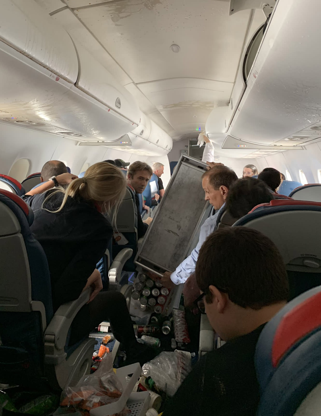
the aftermath of heavy turbulence and the dangers it can present to passengers inside the plane (accessed Nov. 17th, 2021) (https://www.nbcnews.com/news/us-news/3-delta-flight-sent-hospital-after-turbulence-forces-emergency-landing-n971476Links to an external site.)
Another hazard related to weather and climate and can have debilitating effects on a pilot's physiological and psychological conditions is the relationship between air density and altitude, also known as oxygen physiology. The standard atmosphere is the term referring to The relationship between air pressure, temperature, and density with altitude. Normally, human adults inhale 0.5-3 liters of air each breath. However, as altitude increases (as such with a plane), the air becomes thinner and thinner, and oxygen density also decreases. This leads to a physiological condition called hypoxia, which is the insufficient supply of oxygen leading to impaired judgement, lack of focus, and eventually unconsciousness (or being "goofy"). For instance, at an altitude of 18,000 ft, you have around 30 minutes before hypoxia sets in (TUC: time duration of useful consciousness); at 50,000 ft, the TUC is only 12 seconds. To prevent pilots from succumbing to these physiological impacts (which would also affect their performance), pilots flying at higher altitudes (of over 13,000 ft) typically wear oxygen masks.

the necessary equipment for flying at high altitudes, (https://www.nasa.gov/centers/armstrong/features/pilot-breathing-assessment-program-completes-final-phase.html, picture by Carla Thomas, accessed Nov. 17th, 2021)
Speaking of air density and the standard atmosphere, air temperature can also have a huge impact on the performance of the plane and can pose a weather hazard for flying. When the air temperature is hot, such as in the summer, the air density is thin even at lower altitudes. This phenomenon is known as "density altitude”: when Aircraft performance in hot air is similar to performance at high altitudes. Hot air, therefore, causes less air to flow over the wings and less engine/propeller, generating less lift; therefore, planes need a longer runway during hot weather and will take longer to gain altitude. These factors must be taken into account by the pilot to determine if the plane can achieve cruising altitude safely (the height in which the airplane stays for most of a flight) and if the runway is long enough to take off.


 icons at the top right corner of the subsection.